Brand New Garmin Gpsmap 5208 Chartplotter Bluechart G2 Us Coastal 010-00593-01 on 2040-parts.com
Vimont, Laval, QC, Canada
|
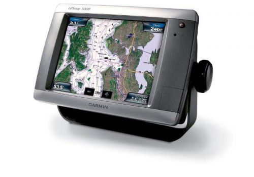
Well established leader for the past 25 years. We are Canadian Garmin Service Center. We sell & service many manufacturers such as Lowrance, Raymarine, Cannon, Icom, and more... The GPSMAP 5208 features an unprecedented touchscreen interface, along with preloaded BlueChart® g2 maps of the U.S. coast and an 8.4" (21.34 cm) screen that makes navigation as easy as pointing your finger. By connecting to the Garmin Marine Network, you can add sonar, radar and weather. For even more advanced features, you can add the optional BlueChart® g2 Vision® card (sold separately). View Detailed Graphics and VideoThe GPSMAP 5208 features highly-detailed BlueChart g2 marine cartography of the coastal U.S., including Alaska, Hawaii and the Bahamas. For other areas, the 5208 has a worldwide basemap with high-quality satellite images in place of more traditional maps. With the SD™ card slot, you can add additional maps without having to connect to a computer. The 5208’s large screen displays crisp, high-resolution graphics so you can easily see where you’re going. To keep tabs on your engine room or other area of your boat, you also can connect a live video feed with the 5208's video input/output options. Add Extras with BlueChart g2 VisionWith the optional BlueChart g2 Vision SD card, you can add a whole new dimension of exceptional features to your chartplotter.
Connect to the Garmin Marine NetworkThe 5208 connects easily to the high-speed Garmin Marine Network, so you can interface with additional MFDs and add remote sensors. Once connected, you can share information between the 5208 and other chartplotters on your boat. You also can add high-powered radar, sonar and XM satellite weather and radio to your system. Charting Basics
|
GPS & Chartplotters for Sale
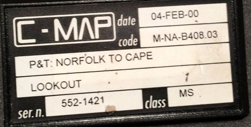 C-map m na-b408.03 - p&t: norfolk to cape lookout - c-card chip(US $45.00)
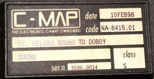 C-map na-b415.01 - st. helena sound to doboy sound - c-card chip(US $32.50)
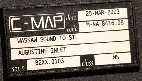 C-map m na-b416.08 - wassaw sound to st. augustine inlet - c-card(US $45.00)
 Raymarine raystar 125 gps ; used
 Garmin 185 gps and sounder
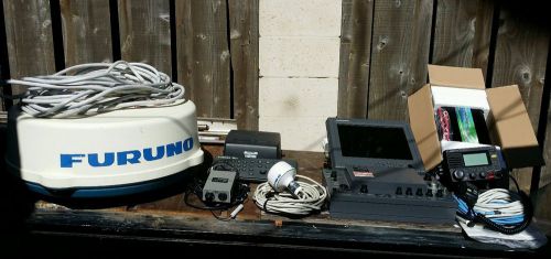 Furuno navnet vx2 system w/ 12 inch monitor 4kw radar, dff 1, & extra's complete(US $2,800.00)
Audi Q3 RS confirmed – but it won’t be badged RS
Wed, 26 Oct 2011Audi Q3 RS confirmed - with 300bhp but no RS badge Back in June we reported that Audi are working on a quick Q3 with something around 300bhp. We didn’t think it would get to market as the Q3 RS (Audi will want to protect the RS badge) but it would almost certainly arrive. Which seems to have been confirmed.
Jeep Wrangler gets light updates for 2011
Thu, 19 Aug 2010Jeep's iconic Wrangler is getting a light update for 2011 with a new interior and a body-colored roof. The subtle changes are part of Chrysler's plans to dramatically upgrade some vehicles while refining its already solid products. In this case, that means the Wrangler gets a redesigned instrument panel, new storage areas and improved storage and ergonomics.
DB9 is fine
Mon, 18 Feb 2013There are some calls you take without hesitation: the president, the pope . . .