Garmin Aera 795 Gps Pacific Brand New on 2040-parts.com
Livermore, California, United States
|
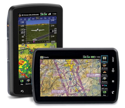
GARMIN AERA 795 GPS PACIFIC BRAND NEW
Experience 3-D navigation, advanced electronic flight bag capabilities and more with aera 795. Viewable in both portrait and landscape mode, the device’s 7” touchscreen puts a wealth of flight information right at your fingertips. See in Virtual 3-DRevolutionary new 3D Vision technology shows a virtual 3-D behind-the-aircraft perspective of surrounding terrain derived from GPS and the onboard terrain database – a feature previously only available in our panel-mount avionics. Simply slide your finger across the touchscreen to rotate the view and show land and water features, obstacles, runways and airport signposts in relative proximity to the aircraft. Using its forward-looking terrain avoidance capability, aera 795 predicts in advance where towers or obstacles may exist and shades the landscape with amber or red overlays to indicate those areas. 3D Vision and other flight data are presented smoothly and continuously thanks to the device’s internal GPS that provides position updates 5 times per second (5 Hz). aera 795’s bright 7" diagonal high-definition sunlight-readable display makes this detailed mapping easy to see in any lighting conditions and works in both portrait and landscape mode. The physical design has been optimized to fit on the yoke or for use as a knee-mounted device. There are only 4 touch keys on the bezel representing "Back", "Menu", "Direct-to" and "Nearest" for quick navigation to the most frequent used functions. All other functions are quickly accessed through Intuitive onscreen icons with labels. This unique touchscreen interface even allows you to quickly pan across the map screen and pinch to zoom. Go Paperlessaera 796 fullfills the role of either a Class I or Class II electronic flight bag, greatly reducing the need to rely on paper charts in the cockpit. Initial georeferenced VFR sectional and IRF enroute charts come preloaded that show your aircraft’s position overlaid directly on the relevant chart. When in IFR map mode, the 795 can display victor airways, jet routes, minimum enroute altitudes and leg distance, much like what’s found on traditional enroute charts. Initial georeferenced Garmin FliteCharts provide approach charts and airport diagrams for the U.S., while pilots who prefer Jeppesen charts and diagrams can use optional Garmin ChartView service, which utilizes Jeppesen’s extensive library to provide global georeferenced charting capabilities. aera 795 also includes a robust document viewer, so you can easily pull up weights and balances, flight manuals, raster charts or a wide range of electronically formatted materials you download to the device. A “scratch pad” feature also allows you to quickly jot down clearances and other pertinent notes while in route, while a checklist viewer allows you to create customized and interactive electronic checklists. Enhance Situational Awarenessaera 795’s built-in terrain and obstacle database not only shows
contours in 3D Vision mode, but also allows for a top-down view of
your entire route. To help you navigate around unfamiliar airports,
SafeTaxi® provides detailed taxiway diagrams and position information
for over 1,000 U.S. airports, while a private airport and heliport
database greatly expands your emergency “nearest” options. FBO, ground
transportation, lodging and other facility information for most U.S.
airports are also available through preloaded AOPA Airport Directory
Data; international pilots may choose to opt for global Expand Your PortableThanks to its 2 serial ports, aera 795 allows for simultaneous connectivity with other hardware. With an optional Garmin GTX 330 Mode S Transponder Interface, you can access Traffic Information Service (TIS) alerts, where available, right on the device while also sending frequencies to a Garmin SL30/40 radio or relaying position reports to other devices. By adding optional City Navigator maps, both helicopter and
fixed-wing pilots add street addresses as waypoints or direct-to
destinations. The device includes an SD™ card slot for easy updates
and expansions; easily keep track of the databases on your aera
through flyGarmin, the online manager that helps you update, manage and purchase the latest aviation data for your Garmin device. FEATURES-
|
||||||||||||||||||||||||||||||||||||||||||||||||||||||||||||
GPS for Sale
 Trimble navigation gps tnl 2000a p/n: 13824-12-0211(US $375.00)
 Lowrance airmap 500 gps(US $100.00)
 Garmin gdl 39 ads-b receiver nib(US $385.00)
 011-00280-10 gns430 gps receiver w/ sv 8130 w/ 90 day warranty(US $6,250.00)
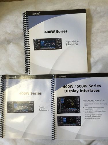 3 garmin 400w / 500w series info kit ops books manual reference gps pilot 2009(US $39.99)
 Garmin ga-35 ga35 ga 35 gps waas antenna p/n 013-00235-00(US $195.00)
Hyundai Blue2: Hyundai Hydrogen Concept
Thu, 31 Mar 2011The Hyundai Blue2 Hydrogen fuel cell concept As you already know from the Kia Naimo report this morning, today is press day at the Seoul Motor Show. So as it’s the home show for Hyundai as well as Kia, we thought we ought to have an interesting Hyundai reveal as well. Step forward the Hyundai Blue2 Concept.
2014 BMW M3 caught testing (video)
Wed, 15 Aug 2012The next generation BMW M3 has been caught on video hot weather testing in Spain. Should debut at the 2013 Frankfurt Motor Show. BMW are readying their sixth-generation M3, codenamed F80, which was spied wearing a thin disguise whilst undergoing hot weather testing in Spain.
Hyundai Equus headed for U.S. market, targets Lexus LS sedan
Mon, 29 Jun 2009Hyundai plans to bring its Equus luxury sedan to the United States next July. About 100 units of the Equus are being evaluated this summer by U.S. dealers and consumers.

